")
")
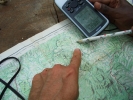
A new project of participatory mapping provides policy makers, NGOs, the private sector, researchers and communities accurate geographical information about the presence, land use and rights of indigenous peoples and other forest-dependent communities in the Congo Basin. It is a repository for participatory mapping data and other work that has been carried out by various organizations in the region over the last decade.
The maps released by the Rainforest Foundation UK (RFUK) join expertise in the fields and geo-spatial technologies and policy development. Authorised users will be able to view community occupation and forest usage alongside other claims on, and users of the forest, such as logging activities, REDD+ projects, palm oil plantations, mining and gas permits, infrastructure projects and strictly protected areas. The map also contains embedded multimedia content which provides insights into the culture, livelihoods and concerns of the communities.